

Technical Short Course
Reading the Earthquake Record: A Field Course in Paleoseismology
August 30 – September 5, 2026
Coos County, Oregon
About
Course Overview

Led by members of the Cascadia Paleoseismology (CPAL) and Community Fault Model (CFM) working groups, this five-day field-based technical short course will expose advanced graduate students, postdocs, and early career professionals to paleoearthquake studies and their application to understanding fault behavior in space and time. We encourage applicants from all geoscience fields and backgrounds, including field and lab-based investigators and numerical modelers, to apply.
Topics to be integrated include principles of subsidence stratigraphy, ecology-based paleoseismic studies, tsunami deposit mapping, trench-based active fault paleoseismology, high resolution lidar topography, and surficial geologic mapping. Participants will be exposed to age dating techniques, methodologies for measuring earth surface displacement, and application of these metrics to determine slip rate, vertical land motion, and earthquake timing. In-the-field activities will provide participants to both fault trench and coastal estuary investigations that emphasize documentation of deformation and evaluating earthquake timing. Finally, this course will facilitate practice with specific data visualization, statistical approaches, and other interpretation techniques using accessible software. The field course will be prefaced with selected online educational materials.
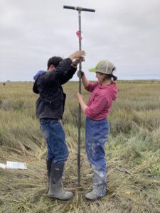
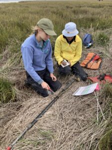
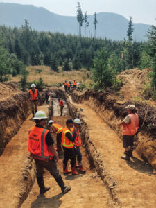
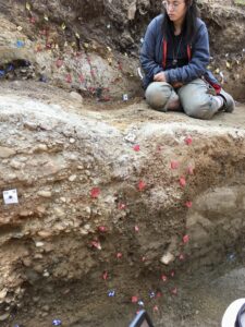
Example photos of coring and trenching fieldwork. Left: Students collect a sediment core from the marsh to look for evidence of land level change during past large earthquakes (photo by Andrea Hawkes). Left Middle: Students work together to describe the sediment core they collected (photo by Andrea Hawkes). Right middle: Agency geologists reviewing paleoseismic trench interpretations (photo by R. Grant Williams). Right: Student working to interpret fault zone stratigraphy to infer past surface ruptures (photo by Colin Amos).
Location
This field methods course takes place in Coos County on southern Oregon’s coast. The course will be based out of University of Oregon’s marine laboratory, the Oregon Institute of Marine Biology (OIMB) in Charleston, a small fishing community situated on the South Slough of Coos Bay. While some time will be spent in the classroom at OIMB, participants will spend 4.5 days in the field in the marshes and adjacent uplands of Coos Bay.
Learning Objectives
By the end of this short course, participants will be able to:
- Identify landscapes that provide relative sea level or active faulting information
- Translate paleoseismic data into an earthquake history
- Identify abrupt land level changes and tsunami deposits from description of tidal marsh stratigraphy from cores.
- Learn approaches to sampling and identification of diatoms, foraminifera and material suitable for radiocarbon from sediment.
- Interpreting exposures in paleoseismic trenches for stratigraphic and structural significance.
- Describe stratigraphy and soils deformed by faulting and identify deposits generated by faulting.
- Gain proficiency in modern methods in lidar scanning and photogrammetry for documenting and interpreting fault trench exposures.
- Undertake detailed surficial geologic mapping of active fault geomorphology using high-resolution lidar topography.
Highlight Your Skills with a Digital Badge: Participants earn a credential through Credly issued by EarthScope Consortium that verifies your achievements. The badge showcases the knowledge and skills you’ve gained and can be shared online, added to resumes, or displayed on professional and social media profiles to support your career growth.
Brief Agenda
Tentative agenda is listed below, and subject to change. Full agenda will be sent along with a participant packet closer to the start of the course.
| Date | Activity |
|---|---|
| Sunday August 30 | • Travel to the Oregon Institute of Marine Biology (OIMB) in Charleston, Oregon where the course will be based. Additional travel details will be shared upon acceptance. • Mandatory Evening Orientation (introductions, outline of the week’s plan and daily routine, and introduction to marsh field work) |
| Monday August 31 | • Marsh Field Day 1 • Evening discussion in the classroom on paleoseismology |
| Tuesday September 1 | • Marsh Field Day 2 • Evening discussion in the classroom on paleoseismology |
| Wednesday September 2 | • Morning: Discussion in the classroom on paleoseismology • Afternoon: Trench orientation in the field |
| Thursday September 3 | • Trench Field Day 1 • Evening discussion in the classroom on fault trenching |
| Friday September 4 | • Trench Field Day 2 • Wrap up session (in the field) |
| Saturday September 5 | • Depart OIMB |
Travel & Lodging
Flights and Ground Transportation
CRESCENT will arrange travel for participants. Participants will fly into either the Eugene Airport (~2.5 hours from OIMB) or the Southwest Oregon Regional Airport (~20 min. from OIMB). Transportation will be provided between the airports and OIMB. Those who are close enough to drive can drive straight to OIMB on Sunday, but please arrive at OIMB in time for the mandatory meeting. You will be reimbursed for mileage. Additional travel details, including arrival time, will be provided after acceptance.
Lodging and Meals
Participants will be housed in shared, multi-bedroom cabins at OIMB. Each cabin will accommodate approximately 3–5 participants. Some bedrooms contain two beds; therefore, participants may be asked after acceptance whether they are willing to share a room. Cabin assignments will be made with attention to participant comfort, and room sharing will be coordinated based on gender identity and individual preferences whenever possible.
Breakfast, lunch, and dinner will be provided at the OIMB dining hall for the duration of the course. On the four field days, a packed lunch will be provided.
Application
Prerequisites
- This course is for graduate students, postdocs, and early career professionals involved in or conducting earthquake research who have specific research or application needs for using or collecting paleoseismic data.
- Applicants are currently based at a U.S. institution. International students who are based at a U.S. institution are welcome to apply. Due to proximity, exceptions may be granted for applicants traveling from Canada.
- Ability to explain how this course aligns with your current research or technical goals.
Note on Fieldwork: Field days will be ~8 hours long and participants must be able to walk on uneven ground for ~1 km while carrying a small pack. The field sites are relatively accessible, and no prior field experience is required. If you have any questions about what the fieldwork entails, please contact Tina Dura (tinadura@vt.edu) or Colin Amos (amosc2@wwu.edu).
Space is limited to 10 participants.
The application closes May 22, 2026 at 11:59 pm Pacific Daylight Time. Notifications will be sent out around the end of June.
For questions contact GEI Program Manager Shannon Fasola (sfasola@uoregon.edu).
Instructors
Cascadia Paleoseismology (CPAL) Working Group
Tina Dura: Virginia Tech
Harvey Kelsey: Cal Poly Humboldt
David Bruce: Virginia Tech
Community Fault Model (CFM) Working Group
Colin Amos: Western Washington University
Andrew Meigs: Oregon State University
Becky Fildes: Western Washington University